Transportation


Throughout the years Lowell has been blessed with great means of transportation. Though some believe that the downfall of business in Lowell happened sometime during the first part of the 20th century when the interurban line "came in 1910 and was crowded out by the state highway about 20 years later." Of course, the trolley had provided a convenient and cheap means of travel but it had failed to help trade and business as the steamboat had gone up and down the river during earlier periods of the community's development.
In the first years of the area's settlement "roads were poor and travel was slow." According to reports, salt boiled at wells on Salt Creek in Muskingum county was carried packhorse fashion to Duncan Falls and floated by canoe down to Adams Township. "Wheat, corn, cider, and other surplus products (from the Lowell area) were loaded on keelboats and floated to New Orleans by the farmer himself or by traders. Some of the best keelboat men on the Muskingum came from Cats Creek.
The first steamer to have gone up the Muskingum, in 1822 or 1823, was a small sidewheel boat of sixty tons. Meeting with little success in running from Marietta to Zanesville this was sold into Lower Ohio trade in 1826. Next came the completion of the slack water improvements (dams, canals, and locks) in 1841, and "steamboat traffic connected the township with markets up and down the Ohio River." These boats came for freight via the mill race to the rear of the several Lowell mills.
As many as a half dozen "early boats" and nearly a score at a later date are reported in 1881 as having been on the Muskingum. At that time the Cassel and General Devol were running for through trade and the Hubbell and a few smaller ones for the local trade.
In 1900, the Sonoma, built in 1897 to replace the old Sonoma, daily plied "the Muskingum in the trade between Marietta and Beverly, touching Coal Run, Lowell and other points. This afforded farmers along the route … the cheapest way to get pressed hay, straw, oats, and other farm produce to market in addition to providing cheap and pleasant transportation for passengers.
"The packet, Lorena, went through Lowell each Friday en route to Pittsburgh and returned on Sunday with stops on both occasions. River traffic declined with the coming of improved highways., and had practically ceased with the completion of State Route 60 (then State Highway 77) in 1930.The decrease in river traffic was likely due to the coming of the Zanesville and Ohio River Railroad which gave the community freight and passenger service. On July 1, 1888, the Zanesville and Ohio River Railroad was completed across the river from Lowell and gave the village rail connection through Marietta and Zanesville. This railroad merged with the Ohio and Little Kanawha and was purchased by the Baltimore and Ohio in 1902. The connection was across the Muskingum via the covered bridge that had been built in 1881. This structure was damaged by a cyclone a year later, washed down the river by the flood. A ferry was operated across the Muskingum River until the completion of the covered bridge.
Next came the interurban to Lowell. The Muskingum River Traction Co., had come up the east bank of the river from Marietta to Devol's Dam in 1905. The line was extended to Fern Cliff about a year later and now, the next section to be completed would bring it to Lowell.
On September 6, 1907, the councilmen of Lowell passed an ordinance that granted to the Muskingum River Traction Co., "its successors and assigns," the right to construct tracks on both Third and Canal Streets and to operate electric cars over them. All work was to be completed in one year from the date of the ordinance.
The Muskingum River Traction Co., was sold shortly after. But on November 22, 1908 the first new street car of the "Parkersburg-Marietta and Inter-Urban Ry. Co." came into Lowell. An enthusiastic crowd greeted its arrival as it clacked down Third Street and came to a stop at the car barns."
There was hourly service for several years from early morning till midnight, on a 15c fare, making possible one's going and returning to and from Marietta at practically any time of day. Then the service schedule was cut to a two-hour basis. Finally, in the effort to get Beverly in, the Company found it impossible to make the desired schedule and the end was soon in sight. Things kept going downhill until the last car ran on Halloween in 1929."About the time the trolley service was to be discontinued, a committee from Lowell went in to intercede with the Company's executives. They were told that a mistake had been made in going on to Beverly. Traffic had been so light that regular runs were uneconomical and there seemed to be no way to make a staggered schedule that would suit both Beverly and Lowell.
Having much to do with the trolley's going out was a continually growing interest in good roads for the possible use of autos. This had gained considerable momentum as early as the 1920s. At first, it consisted of almost any kind of effort to get out and stay out of the mud. Gradually, it turned to grading and graveling. One of the first stretches of road to be graveled was up to the hill to the southwest. Here, just beyond the Catholic church, a connection was made over a longer piece of gravel by way of the Marietta Concrete Corporation plant into Marietta. This afforded ready access to the county seat in all kinds of weather and it was used during the time of concreting the main road, now State Route 60. The first piece of concrete road was constructed during 1916 or 1917 from the center of town to the foot of the hill at Greenlawn Cemetery and across southward to the river highway.
Proper grading and then graveling preceded the concreting of State Route 60 (then State Highway 77) in the late 1920s. Several citizens of Lowell contributed to the gravel fund for improving this road to March Run Hill where connections were made on to Marietta. When that was done Lowell’s citizens reported that they had really began to get out of the mud. Next, the community got some help from the township, then the county, and finally the state.
Before and during the years that the streetcar line ran through Lowell, the road up the Muskingum from Marietta to Zanesville (now State Route 60), ran much closer to the river's bank in most locations than it does now.
The best road from Lowell to Beverly, the one almost everyone used, came into Lowell from Marietta about where it does now. People would then cross the lower canal bridge and go along the river bank on the island to the upper canal bridge into Upper Lowell. The road ran through Upper Lowell not far from the bank of the river, and was located much closer to the river all the way west to Beverly.
There was another road from Lowell to Beverly which ran through the village along Main Street to the present junction of State Route 60 and Cats Creek Road. The road went to the right at this junction out past the cemetery to "the plains" and on over the hill, while the street car lines followed what is now the location of State Route 60.When the interurban service to Lowell was discontinued in 1929, the tracks were taken up, highway engineers availed themselves of the fills, cuts, and grades made by the traction company over which to relocate much of State Route 60.The present road system includes several good townships roads and county highways in and out of Lowell, as well as State Route 530 across the hills eastward to Warner where a connection is made with State Route 821 north and south.
The first automobile was purchased and put into use locally in about 1900. It was "an old chain drive affair which caused everybody to look and every horse on the street to shy.” The next was a Maxwell that came in 1903 or 1904. This was almost as noticeable as the first, to horses especially. Eventually, there was organized a local automobile club of some 12 or 15 members. Among its purposes were those of the owners' or drivers' desires to work for good roads. If and when they could get no action from road officials in other ways, they "just took their shovels, doffed their coats, even on Sunday afternoons, and put on gravel where it was most needed."
This local group seems to have been at least partially responsible for the widening of the Narrows, two or three miles east of Lowell on the way to Marietta. At this particular point, for quite a stretch, there was one-way traffic with the view completely obstructed around the corners. The customary way to get through was to "stop, blow your horn, and if nobody blew back proceed to the next corner. If somebody answered your honk, you waited until he came by."
This narrows, between the river and the steep hillside, was made even more difficult due to its accommodating the trolley from and to Marietta. When the trolley went out in 1929, there was ample space for a regulation-width roadbed.
Farmers and residents along the river had agitated for improvements to navigation for years before work on locks and dams for the entire Muskingum River began in the Spring of 1837. The work was completed in 1841 at a total cost of $1,627,018.20.Rivalry along the Muskingum for the location of the dams and the canals, which would contain locks, was high and sometimes bitter. The lock and dam was a prize sought by every community in the belief that the resulting commerce would bring prosperity and growth.
Selecting the site for Lock No. 3 in the Lowell area was no exception. Residents on the west side of the river made a strong bid to have it located there, according to one old record. With enthusiasm, they plotted a city in their fields that theirs would be the location chosen.
Their hopes were dashed, when excavations began for the dam abutment about 1000 feet above its present site. But, Perez Barnum Buell, founder of Lowell, was unhappy over this location. Having considerable political influence, he persuaded the right people in Washington to abandon construction and move the whole operation downstream opposite his holdings.
Unlike the system in the Ohio River, almost all the Muskingum dams are built across the river from bank to bank. A canal, like a by-pass, is dug around the dam with the lock located in the canal.
Due largely to Buell's influence, the canal at Lowell is over a mile long, the longest one on the river.
All of these early dams were of wood and stone. Harley C. Frye, of Lowell, a government engineer, described these in his letters: "All gravel and lit was first cleared from the river bottom down to bed rock." This was accomplished by manpower, wheelbarrows, shovels, and horse-drawn wagons.
Huge trees were then felled from the forests and dragged by yokes of oxen to the river where they laid side by side in a row, clear across the bed of the river. "After this later of trees was laid down, space between the trunks was filled in with rocks and the hole covered with enough stone to make it comparatively level. Then, another layer of trees and rocks was placed on top of them."
This procedure was repeated until the last row of trees was above the water. "When this occurred, the entire flow of water would be going through among the rocks and timbers. They would then begin building a shaped crib."
Each crib was about 10 feet long, made of the stoutest timbers placed sufficiently close together to hold the heavy stones with which they would be filled.
The horizontal logs in the cribs were allowed to extend on one side and were firmly embedded in the stone abutments that had been built on each bank."
This gave the dam more stability. When all this was completed, small stones and gravel were boated above the dam and unloaded. The current carried them downstream to lodge against the large stones and among the timbers, thus building up and firming the structure until the water rose sufficiently to flow over the top of the completed dam.
For 123 years, the Muskingum had a checkered history of being orphaned, and adopted, by the state, by the federal government, and claimed and disclaimed.
On October 8, 1958, the federal government conveyed the system, then useless from neglect, rust, and decay, back to the State of Ohio. With the conveyance was a check for $235,000, which was the estimated cost to breach the 11 dams and retire the system.
Due to the influence and efforts of the Muskingum Valley Improvement Association and prominent businessmen, the federal and state governments worked on restoring the locks and dams between 1964 and 1966.A number of deaths have occurred in the waters at Lowell. On August 15, 1937, Robert Weisent, 15-year-old son of Mr. and Mrs. Walter Weisent drowned in Cat's Creek, a 1/2 mile from the village, when he waded into a step-off in the creek bed.
Unable to swim, he sank into the waters of the stream and was drowned when his friends failed in their efforts to drag him to safety.
The Weisent family was attending the Rupple Family Reunion near the D. B. Stanley home at the time. Mrs. John Shawhan heard the calls of his friends and flagged a passing motorist for aid.His uncle, Oscar Rupple, made several dives into the creek before he recovered the body. Artificial respiration failed to revive him. A verdict of death by drowning was pronounced by Coroner R. W. Riggs.
On April 1, 1963, Hugh Peters of Coal Run lost his life in the Muskingum River when his outboard motorboat went over the dam at Lowell.
Lawrence Ball, chief of the Lowell Fire Department at the time, said a man identified as Captain Burrows of Lowell reported he saw Peters' motorboat go over the dam at about 1:35 p.m. The wooden boat reportedly broke up as it went over the dam and dropped about 10 feet. He reported the boat spun around several times as it neared the dam but that the motor was still running when the craft plunged over the dam. He said Peters appeared to be slumped over in the boat at the time.
Washington County deputy sheriffs and Lowell volunteer firemen searched through out the afternoon for his body before giving up the hunt for the day. The river was reportedly high and the current very swift, making searching, especially near the dam, difficult and dangerous.
A few pieces of wood from the boat and a life jacket were found. On April 22, 1963, the body of Hugh Peters was found floating in a pile of driftwood in the Muskingum River about five miles north of Marietta.
Lowell Bridge


The first bridge across the Muskingum River at Lowell was built in 1880. It was a 15
foot wide wooden, covered bridge consisting of three spans, 155 feet each, with steep, sloping ramps at each end. It was completed for a cost of $10,000. It was built by A. P. Steel and F. B. Townsend.
This bridge was short-lived as it was blown down by high winds during a summer storm the next year.
The following year, 1882, it was rebuilt. The contract permitted the builders to use the same piers and as much material from the first bridge as was undamaged. The cost for this was $3,000. It was built by John Hall, Jacob Becker, and B. P. Bailey. This bridge was fifteen feet smaller than the first bridge.
The flood of 1884 swept away two spans of this bridge. The spans were rebuilt that
same year by Daniel Wilking at a cost of $1,800. The bridge had a large sign over it
that read "Fine for driving over 10 miles per hour or more than 20 head of stock at one time."
The interior of the covered bridge was a popular place for signs of all types. Advertisements of local merchants and political aspirants, traveling medicine shows, and steamboat excursions.
At first, this bridge was lighted by three, flickering oil lamps that made small circles in the blackness. When gas lines were put in at Lowell, a few gas lights were installed, but these were mostly broken or out of order much of the time.
The bridge stood with only normal repairs for 29 years. Then came the flood of 1913, which destroyed every bridge across the Muskingum River.
A new bridge was built on the piers of the old bridge. This new bridge was 15 feet wide, and was made of steel and concrete. It cost less than $30,000 to build.
In February 1937, the bridge was repaired. The main floor, which was composed of
blocks of wood, buckled in many places during a flood. These were removed and re
placed. Piers and approaches were not damaged, nor were the canal bridges.
In October 1965, the bridge was closed for several days while repairs were made to
damage done by a piece of heavy equipment trying to cross. The repairs cost in excess of $5,800.
In April 1968, at the request of the county engineer, the bridge was examined by a firm from Harrisburg, PA. Their report stated that, "the bridge was not designed right to start with," and was good for only about a three-ton load limit. The two end sections were then reinforced with I-beans with the possibility of a new bridge discussed.
Cecil Stacy, the County Engineer at the time, said that a new bridge would cost around $700-750,000 and that there was no money available with which to build one.
It was about this time that traffic lights were installed at each of the bridge approach. The bridge had been a prime fender-scraper.
This bridge was torn down in February 1977.
The current bridge was built for $2.9 million, and was finished in October 1976. The
project was financed with 70 percent federal funds, and 30 percent local funds.
In 1970, engineers started surveying to find what they considered the best location for a new bridge at Lowell. These surveys resulted in five different proposed locations for the new bridge.
The first suggested site was for the bridge to cross the canal and river above the village which would have cost an estimated $1,453,100 and apparently would have interfered with no buildings or homes.
The second suggested proposal would have brought the approach through the village and terminated it at Third and Walnut Streets. This would have taken out a number of houses and have cost an estimated $1,651,400.
The third location, would have had the bridge cross the river just below the end of
the canal at the tip of the island, and enter the village at McClain Street. This survey showed an off ramp onto the island and a sizeable stretch of new road needed on the far side of the river - the existing road at the time was apparently not suitable. The estimated cost of this plan was $1,414,700, and would take out one already closed business place.
The fourth proposed site was for the bridge to cross the river to the island with a drawbridge over the canal at Walnut Street for an estimated cost of $1,629,200. This location would have sacrificed one dwelling on the island.
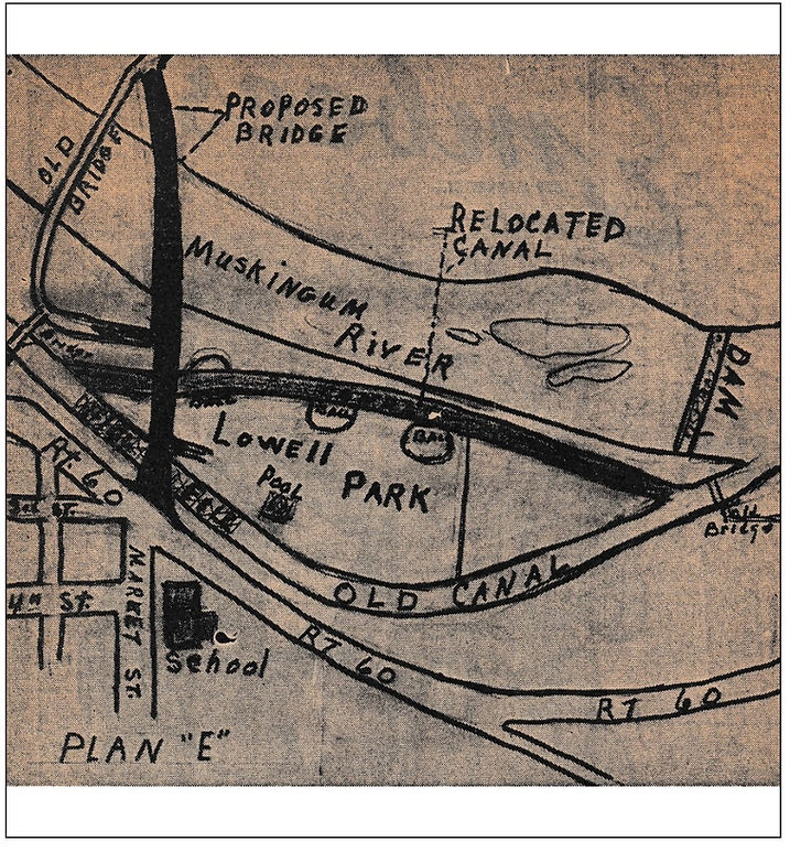
The fifth proposed location, AKA Plan E, was for the bridge to enter the village at Market Street, the corner on which Lowell Elementary School stands. The estimated cost of this site was $1,339,900. If this location was chosen, two or three dwellings, some summer cottages, and a few trailer homes would have been sacrificed. In addition, the Park and recreation area on the Island, would have lost one ball diamond and a part of another.
This plan would have also necessitated the digging of a new canal along the far side of the island and the filling in of several hundred feet of the existing canal. The section of the old canal that would have been left intact would have then flown through a culvert to join with the new canal.
This plan received federal, state, and county stamps of approval. The Mayor and five of the six councilmen supported the County Commissioners. Rolla Hartshorn was the lone councilman who opposed the plan.
The plan was opposed by nearly all of Lowell's residents. Lowell's prominent businessmen, including Robert Peoples, Ralph Mahoney, Arza Augenstein, Cecil Jarrell, and L. M. " Pete" Ball (who was also Fire Chief), all went on record to oppose the plan. Former Mayor Clarence Luton also spoke in opposition.
In the end, the third location was selected, and the current bridge was built.